
One World
Nations Online
|
|
One World Nations Online |
|
Home  |
___ Hungary |
 Lake Balaton at Tihany, Hungary. Lake Balaton is the largest lake in Central Europe. Image: Taki Steve |
 Location map of Hungary With an area of 93,028 km², the country is about the size of Portugal, or about the same size as the U.S. state of Indiana. Hungary has a population of almost 10 million people (in 2015), official language is Hungarian. Largest city and the national capital is |
Republic of Hungary | Magyar Koztarsasag |
Country Profile |
Background: Hungary was part of the polyglot Austro-Hungarian Empire, which collapsed during World War I. The country fell under communist rule following World War II. In 1956, a revolt and announced withdrawal from the Warsaw Pact were met with a massive military intervention by Moscow. In the more open GORBACHEV years, Hungary led the movement to dissolve the Warsaw Pact and steadily shifted toward multiparty democracy and a market-oriented economy. Following the collapse of the USSR in 1991, Hungary developed close political and economic ties to Western Europe. It joined NATO in 1999 and is a frontrunner in a future expansion of the EU. (Source: CIA - The World Factbook) |
Official Name: Magyar Koztarsasag short form: Magyarország int'l long form: Republic of Hungary int'l short form: Hungary ISO Country Code: hu, hun Time Zone: Central European Time (CET) Actual Time: Mon-Apr-15 19:06 Local Time = UTC +1h (Summer: UTC +2) Country Calling Code: +36 Capital City: Budapest (est. pop. 2 million) Other Cities: Debrecen (220,000); Miskolc (208,000); Szeged (189,000); Pecs (183,000). Government: Type: Republic. Constitution: August 20, 1949. Substantially rewritten in 1989, amended in 1990. Geography: Location: Central Europe, northwest of Romania. Area: 93,028 km² (35,918 sq. mi.) Terrain: Mostly flat, with low mountains in the north and northeast and north of Lake Balaton. Climate: Temperate; cold, cloudy, humid winters; warm summers. People: Nationality: Hungarian(s). Population: 9.8 million (2015) Ethnic groups: Magyar 92%, Romany 4% (est.), German 2%, Slovak 1%, others 1%. Religions: Roman Catholic 68%, Calvinist 21%, Lutheran 4%, Jewish 1%, others, including Baptist Adventist, Pentecostal, Unitarian 3%. Languages: Magyar 98%, other 2%. Literacy: 99%. Natural resources: Bauxite, coal, natural gas, fertile soils, arable land. Agriculture products: Wheat, corn, sunflower seed, potatoes, sugar beets; pigs, cattle, poultry, dairy products. Industries: Mining, metallurgy, construction materials, processed foods, textiles, chemicals (especially pharmaceuticals), motor vehicles. Exports - commodities: machinery and equipment 53.5%, other manufactures 31.2%, food products 8.7%, raw materials 3.4%, fuels and electricity 3.9% (2012 est.) Exports - partners: Germany 28%, Romania 5.4%, Slovakia 5.1%, Austria 5%, Italy 4.8%, France 4.7%, UK 4%, Czech Republic 4% (2015) Imports - commodities: machinery and equipment 45.4%, other manufactures 34.3%, fuels and electricity 12.6%, food products 5.3%, raw materials 2.5% (2012) Imports - partners: Germany 25.8%, China 6.7%, Austria 6.6%, Poland 5.5%, Slovakia 5.3%, France 5%, Czech Republic 4.8%, Netherlands 4.6%, Italy 4.5% (2015) Currency: Forint (HUF) More Hungary statistical data. |
|
Note: External links will open in a new browser window. Official Sites of HungaryHungarian ParliamentInformation System of the Hungarian National Assembly. Miniszterelnöki Hivatal Office of the Prime Minister. Nemzeti Kulturális Örökség Minisztérium Ministry of Culture and Education (in Hungarian) Ministry of Foreign Affairs of Hungary MOFA Hungary with comprehensive information about the ministry and Hungary. Diplomatic Missions Embassy of Hungary in the U.S. Washington D.C. Hungary's Diplomatic Missions Abroad List of Hungarian Missions Abroad. Foreign Diplomatic Missions in Hungary List of Foreign Missions in Hungary. Statistics Központi Statisztikai Hivatal Hungarian Central Statistics Office. Hungary key statistical data. MapsPolitical Map of Hungary. Map showa the 19 Hungarian counties and their capitals. Searchable map and satellite view of Hungary. Searchable map and satellite view of Hungary's capital city Budapest. Political Map of Europe.  Hungarian Parliament Building on the bank of the Danube in Budapest. Image: Dwight79 |
NewsSome European governments and institutions have criticised a controversial media law, introduced in 2011. The legislation created a Media Council, with a chairperson appointed by the prime minister (Viktor Orban), known for his brand of nationalist populism.Magyar Távirati Iroda Rt. Hungarian News Agency. hvg.hu Hungarian news site. Budapest Times National and international news. Budapest Week Budapest Online magazine. Hungarian Free Press English-language non-partisan online news source. The Hungarian Quarterly English-language journal. |
Bookmark/share this page |
Arts & CultureCenter For Culture & Communication. Hungarian Culture Homepage Offers data from 2 500 cultural organisations. National Szechenyi Library The National Library. Sziget Festival Best of world music. Victor Vasarely Vasarely was a Hungarian-French artist, known as the "grandfather" and leader of the op art movement. Museums Hungarian National Gallery The country's national art museum. Hungarian National Museum Museum about the history and the cultural heritage of the country. Museum of Fine Arts Budapest The museum has a number of collections of Ancient Egyptian art, Classical antiquities, and old master paintings. Institute of Contemporary Art Contemporary art and culture in the city of Dunaújváros. Holocaust Museum Budapest To the Memory of the Victims of the Hungarian Holocaust. |
 Vasarely sculpture in the city of Pécs in Hungary. Image: Váradi Zsolt |
Business & EconomyMagyar Nemzeti Bank National Bank of Hungary Budapest Stock Exchange Chamber of Commerce and Industry of Budapest __Transportation Airlines Malév was the flag carrier and principal airline of Hungary from 1946 to 2012. The airline ceased operations on 3 February 2012. CityLine Hungary Hungarian charter airline with its hub at Budapest Ferihegy International Airport. Sólyom Hungarian Airways Hungarian airline founded in 2013 after Malév Hungarian Airlines ceased operations. Until now (2017) there is no service by the airline. Travel Service (Hungary) Airline based in Budapest, a sister airline of Travel Service Czech Republic. Wizz Air Hungarian low-cost airline. Airport Budapest Ferenc Liszt International Airport (BUD) Budapest's international airport formerly known as Ferihegy International Airport. Rail MAV The Hungarian Railways. MAV railroad connection |
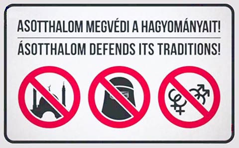 "Message to Illegal Immigrants from Hungary" Prohibition sign propagated by the mayor of Asotthalom, a village in Csongrád County, Hungary. |
Travel and Tour Consumer Information
Destination Hungary - Country GuidesHungary The Hungarian Tourism Agency provides travel and tourism information. Hungary.hu Comprehensive Hungary portal site with country information. Hungarian Home Page A guide to regions, cities and towns. Regions Györ-Moson-Sopron Region Official website of the Gyor-Moson-Sopron County. City Guide Budapest Web site of the Tourism Office of Budapest provides travel and tourism information the capital city. |
Education & SienceCentral European University Social sciences and humanities Semmelweis University of Medical Sciences Official website with information about its faculties. Technical University of Budapest The official website of the university. Science Hungarian Academy of Sciences Hungarian science. Konkoly Observatory Want to know something about variable stars? |
Environment & NatureGreenfo.hu Hungarian Environmental Portal, it serves also as a non-profit green news-agency. Greenpeace Hungary Hungarian section of Greenpeace. InfoLink The site provides information in Hungarian, German, Slovak and English on the state of the environment of the West and North Transdanubian regions. Magyar Természetvédök Szövetsége Friends of Earth Hungary (in Hungarian). REFLEX (Györ) Environmental Protection Society (in Hungarian). |
 Sweep Well at Hortobagy © Photo Archive HNTO |
HistoryCorvinus Library - Hungarian History Comprehensive source of Hungary's History. István Lázár: Hungary - A Brief History Extensive disquisition on Hungary's history. |
SearchOpen Directory Project: HungarySources and additional Information on HungaryBBC Country Profile: Hungary EU member countries: Hungary GlobalEDGE: Hungary OEC: Hungary Wikipedia: Hungary The World Factbook -- Hungary |
 |
Other Countries of Eastern Europe: Belarus | Bulgaria | Czech Republic | Moldova | Poland | Romania | Russian Federation | Slovakia | Ukraine |
One World - Nations Online .:. let's care for this planet Promote that every nation assumes responsibility for our world. Nations Online Project is made to improve cross-cultural understanding and global awareness. More signal - less NOISE |
| Site Map
| Information Sources | Disclaimer | Copyright © 1998-2023 :: nationsonline.org |
