
| Home |
|
|
|
___ Historical Map of Africa in 1885 |
|
| The image shows a political map with the knowledge about Africa in the year 1885, with a lot of ill-defined borders throughout the continent because the Scramble for Africa, the partitioning of Africa by the European powers has not yet really begun. Depicted on the map is the African continent at the end of the 19th century, in the then prevailing opinion that the last white spots of terra incognita has almost vanished from the maps of the Black Continent. North Africa The Kingdom of Morocco is ruled by Hassan I of Morocco, a member of the Alaouite dynasty. Algeria is occupied by France and the Regency of Tunis (Tunisia) was a colonial protectorate of France. Tripoli / Fezzan (Libya) was a Turkish vilayet (wilayah / regency) part of the Ottoman Empire, the oases in the Libyan Desert to the south were under control of Arab Senussi (Sanusi) sheiks. Egypt is a tributary state of the Turkish empire. Egypt itself is ruled by a Khedive comparable to a Viceroy. After the nationalist Urabi Revolt of 1882, Britain invaded Egypt in support of the Khedive Tewfik Pasha, and would continue to occupy and dominate the country for decades. During this period, the Muhammad Ali Dynasty under Tewfik Pasha and his son Abbas Hilmi Pasha continued to rule Egypt and Egyptian Sudan (Sudan), whilst still nominally (de jure) under Ottoman sovereignty until 1914. West Africa The region of Western Africa and parts of Central Africa south of the Sahara and north of the 10° latitude are named Soudan on the map. South of Soudan lies Guinea. Ashantee Kingdom (Ashanti) was one of the few African states which were able to offer serious resistance to European colonizers. Between 1823 and 1896, Britain fought four wars against the Ashanti kings (in the Anglo-Ashanti Wars). In 1900, the British finally defeated the kingdom and incorporated it into the Gold Coast colony as a protectorate. Masina (Massina Empire) a Fulbe Jihad state with its capital Hamdullahi. Timbuctoo (Timbuktu) of today Mali. Bambarra Kingdom also Bamana Empire with its capital city of Segu (Ségou, Mali) Dahomey, Dan Ho Me the ancient Kingdom is located in the south of today Benin. Freetown in Sierra Leone is a British Crown Colony since 1808. Senegambia is divided among French forces in today Senegal and the British forces in today The Gambia; not to be confused with the post-colonial Senegambia Confederation (1 February 1982 - 30 September 1989). Songhay, region of the Songhai people and the pre-colonial Songhai Empire one of the largest African empires in history (c. 1340–1591) in present day Niger and Burkina Faso. |
Central Africa Loango; the Kingdom of Loango was one of the oldest and largest kingdoms of the region. The time of its foundation by the Vili people (Bavili) is unknown so it is believed that it was in the mid of the 15th century. Loango was situated in the basin of the Kouilou and Niari rivers (today in the southwestern region of Republic of the Congo). At its height in the seventeenth century the country stretched from Cape St Catherine in the north to almost the mouth of the Congo River. In 1885 Portugal had then exercised for centuries a somewhat uncertain sway on Loango, but has benefited from the trade of ivory and slaves. East Africa Abyssinia, the Ethiopian Empire (Ethiopia) is ruled by the Negus (King of Shewa) Menelik II (Sahle Selassie). Galla Land (Land of the Oromo people (Galla) of today Ethiopia and Northern Kenya) Southern Africa Orange Free State 1854–1902 today one of the provinces of South Africa Cape Colony, established by the Dutch East India Company in 1652, occupied by the British in 1795, and remained in the British Empire until the formation of the Union of South Africa in 1910. Damaraland was a name given to the north-central part of what later became Namibia, inhabited by Herero-speaking people, who in the 19th century were often referred to by outsiders as "Damaras. Great Namaqualand, in the Karas Region of today Namibia. Transvaal (Afrikaans, lit. beyond the Vaal River) was colonized by Boer settlers who left the British-dominated Cape Colony in the 1830s and 1840s. Bookmark/share this page |
 One World - Nations Online countries of the world |
|
|
||
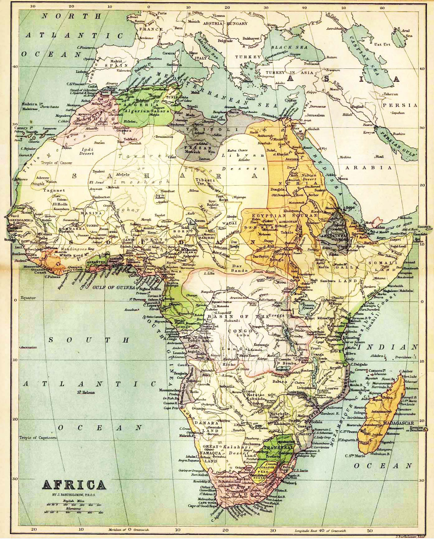 Historical Map of Africa by J. Bartholomew, F.R.G.S. John Bartholomew (1831 – 1893) was a Scottish cartographer, born in Edinburgh. |
One World - Nations Online .:. let's care for this planet Made to improve cross-cultural understanding and global awareness. |
| Site Map
| Information Sources | Disclaimer: Privacy Policy, etc. Contact: [email protected] | Copyright © 1998-2016 :: nationsonline.org |