
|
|
___ Political Map of Albania | |
About Albania |
|
| Map is showing Albania, a republic on the Balkan Peninsula in southeastern Europe bordering the Adriatic Sea and the Ionian Sea in west, Montenegro in north, Serbia (Kosovo) in north east, the Republic of Macedonia in east, and Greece in south east. Albania shares maritime borders with Croatia and Italy. With an area of 28,748 km², Albania is slightly smaller than Maryland, or only half the size of Croatia. The country has a population of 2,890,000 people (2015), Capital and largest city is Tirana. Spoken language is Albanian. Geography of Albania Albania has three primary topographical areas: a coastal plain, an interior mountainous region, and an interior plain. The interior of the country is mostly mountainous and approximately 36% is densely forested. The highest mountain in the country is Korab with 2,764 m (9,068 feet), its ridges are forming a section of the border between Albania and the Republic of Macedonia. The Albanian plains are extensively planted with olives, citrus fruits and vineyards. There are numerous lakes in the country, the biggest is Shkodra, with 370 km² the largest lake in the Balkan Peninsula, it is shared with Montenegro. The exceptionally deep lake Ohrid (294 m; 931ft) in the eastern part of the country is shared with Macedonia. The Ionian coast, particularly the "Riviera of Flowers," from Vlora to Saranda, is both rugged and beautiful, featuring some of the most picturesque scenery in the country. Airport Tirana International Airport Nënë Tereza (IATA code: TIA), also known as Rinas Airport) is Albania's only international airport, located 25 kilometres (16 miles) northwest of Tirana near the town of Rina. Seaport The principal port is located in Albania's second largest city of Durrës. |
 Bookmark/share this page |
 One World - Nations Online all countries of the world |
|
|
||
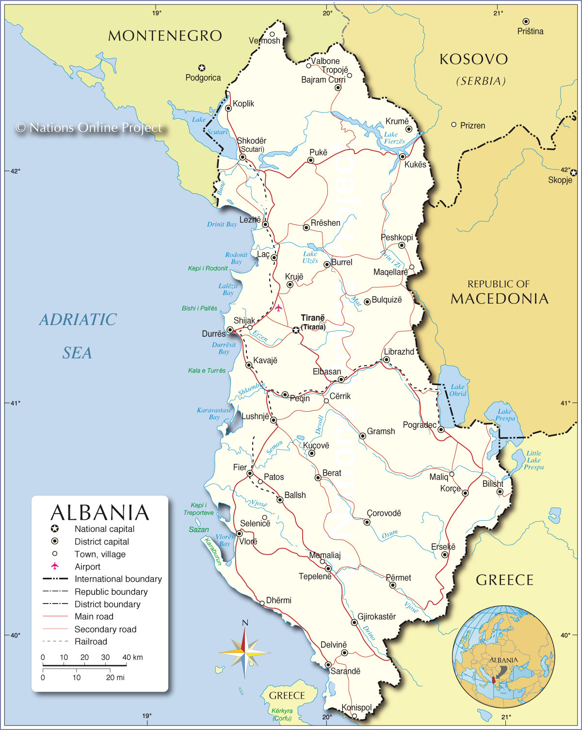 Political Map of Albania Map based on a UN map. Source: UN Cartographic Section |
|||||||
| Cities and towns in Albania The Map shows the location of following Albanian cities: Bajram Curri, Ballsh, Berat, Bilisht, Bulquizë, Burrel, Cërrik, Çorovodë, Delvinë, Dhërmi, Durrës, Elbasan, Ersekë, Fier, Gjirokastër, Gramsh, Kavajë, Konispol, Koplik, Korçe, Krujë, Krumë, Kuçovë, Kukës, Laç, Lezhë, Librazhd, Lushnjë, Maliq, Maqellarë, Memaliaj, Patos, Peqin, Peshkopi, Përmet , Pogradec, Pukë, Rrëshen, Sarandë, Selenicë, Shijak, Shkodër (Scutari), Tepelenë, Tiranë (Tirana), Tropojë, Valbone, Vermosh, and Vlorë. |
More about Albania: Cities: Country: Albania key statistical data. Continent: Political Map of the Mediterranean Region. Political Map of the Balkans. |
Current Weather Conditions Tirana:
|
Related Consumer Information: |
||||
Maps of other Countries in Southern Europe Bosnia and Herzegovina Map, Croatia Map, Cyprus Map, Greece Map, Italy Map, Macedonia Map, Vatican City State Map, Montenegro Map, Portugal Map, Serbia Map, Slovenia Map, Spain Map, Turkey Map |
One World - Nations Online .:. let's care for this planet Every nation is responsible for the current state of our world. |
| Site Map
| Information Sources | Disclaimer: Privacy Policy, etc. Contact: [email protected] | Copyright © 1998-2021 :: nationsonline.org |
