
| Home |
|
|
|
___ Political Map of Belgium |
|
About Belgium |
|
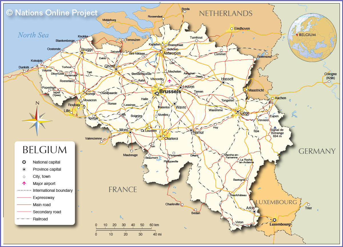
| Map is showing Belgium, officially the Kingdom of Belgium, a federal monarchy in Western Europe bordered in northwest by the North Sea. The country is clockwise bordered by the Netherlands in north, Germany in east, Luxembourg in southeast, and France in south and southwest. With an area of 30,528 km² compared, Belgium is a third the size of Portugal (92,090 km²), or about the size of the U.S. state of Maryland. The mostly flat country offers three main geographical regions, the flat coastal plain in the north-west, a central plateau, and the Ardennes, a region with a more rough terrain, with ridges and ranges of hills, covered by thick forests. Belgium has a population of 11 million people (2012), capital city is Brussels, with a population of 186,000 people, but more than 1 million people live in Brussel's greater metropolitan area. Spoken languages are Dutch, French, and some German. Depicted on the map is Belgium with surrounding countries, international borders, major cities, expressways, main roads, railroads, and major airports. Brussels Airport, (IATA Code: BRU) is the primary international airport in Belgium, more than 80% of the airways traffic is handled by Brussels National. |
 Bookmark/share this page |
 One World - Nations Online countries of the world |
|
|
||
 Map of Belgium |
| Cities and Towns in Belgium: The map shows the location of following Belgian cities: Largest Cities (pop. 2012/13): Antwerpen (Antwerp; 512,000), most populous city and one of the largest seaports in Europe; Ghent or Gent (235,000), Charleroi (213,000); Liège (189,000), Brussels (City proper 186,000) Other cities and towns in Belgium: Aalst, Aarschot, Arlon, Ath, Bastogne, Beaumont, Blankenberge, Brasschaat, Brugge, Dendermonde, Diest, Diksmuide, Dinant, Eeklo, Eupen, Florennes, Halle, Hasselt, Huy, Ieper (Ypres), Kapellen, Knokke, Koksijde, Kortemark, Kortrijk, La Louvière, La Roche-en-Ardenne, Lessines, Leuven, Lier, Lommel, Marche-en-Famenne, Mechelen, Mons, Mouscron, Namur, Neufchâteau, Nivelles, Oostende, Oudenaarde, Philippeville, Poperinge, Roeselare, Ronse, Schoten, Sint-Niklaas, Soignies, Spa, Tielt, Tienen, Tongeren, Torhout, Tournai, Tuin, Turnhout, Verviers, Veurne, Vilvoorde, Virton, Waremme, Waterloo, Wavre |
More about Belgium: Cities: Country: Continent: |
Brussels Weather Conditions
|
Related Consumer Information: |
||||
Major Cities in Western Europe Amsterdam, Berlin, Bern, Cologne, Frankfurt, Hamburg, Luxembourg (City), Monaco, Munich (München), Nice, Paris, Rotterdam, The Hague, Vaduz, Vienna (Wien), Zurich Searchable Maps of other Countries in Western Europe: Austria | France | Germany | Liechtenstein | Luxembourg | Netherlands | Switzerland Maps of other Countries in Western Europe: Austria Map, France Map, Germany Map, Netherlands Map, Switzerland Map |
|||||||
One World - Nations Online .:. let's care for this planet Every nation is responsible for the current state of our world. |
| Site Map
| Information Sources | Disclaimer: Privacy Policy, etc. Contact: [email protected] | Copyright © 1998-2021 :: nationsonline.org |
