
| Home |
|
|
|
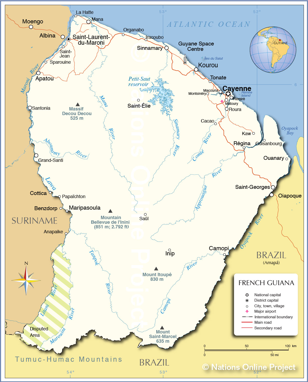
___ Political Map of French Guiana (French: La Guyane Francaise or Guyane) |
|
About French Guiana |
|
| French Guiana is a French overseas region on the northeastern coast of South America, bordering the North Atlantic Ocean, countries with international borders to French Guiana are Brazil and Suriname. With an area of 83,534 km² the country is about the size of Austria, or slightly larger than the U.S. state of South Carolina. French Guiana's landscape offers a narrow coastal plain dotted with swamps and marshes, where the majority of the people live, to a dense, near-inaccessible rainforest in the interior. The interior consists mostly of rolling hills, the land gradually rises to the modest peaks of the remote Tumuk Humak mountains in south along the Brazilian border area. The mountain range is part of the Tumucumaque Uplands of the Guiana Shield, they form the divide between the biogeographical system of the Amazon Basin and that of the Atlantic coastal area of the Guianas. French Guiana's highest elevation is at Bellevue de l'Inini in Maripasoula province with 851 m (2,792 ft.). The French overseas region has only 0.13% of arable land , and 0.04% permanent crops, it consists to 90% of forest. French Guiana has a tropical rainforest climate, its hot and humid with little seasonal temperature variation but is moderated by trade winds at the coast. Dry season from August to December; rainy season is December and January, alternating sunshine and tropical showers in January and February, April to July rainy season again. Guyane has a population of just 224,000 people. The official language is French, but a number of other local languages are spoken including French Guiana creole, six Amerindian languages, and four Maroon dialects. Capital city is Cayenne. The ESA Space Center is located near the city of Kourou. Major rivers in French Guiana are the Marowijne (Moroni) River, which marks the (disputed) border between French Guiana and Suriname, the Litani River, a tributary of the Maroni River, forms part of the semi-official southern boundary between French Guiana and Suriname. The Oyapock River forms most of the border between French Guiana and Brazil (Amapá state). Map is showing the South American country with international borders, the territorial capital Cayenne, province capitals, major towns, and villages, main roads, the location of the region's main international airport, Cayenne – Félix Eboué Airport (IATA code: CAY) located in the commune of Matoury, 13 km (8 mi) southwest of Cayenne. |
 Bookmark/share this page |
 One World - Nations Online All Countries of the World |
|
|
||
 Political Map of French Guiana |
|||||||
| Cities and Towns in French Guiana Map shows the location of following cities, towns and villages in French Guiana: Apatou, Cacao, Camopi, Cayenne (capital and largest city, pop. 116,000 inhabitants in the metropolitan area), Grand-Santi, Guisanbourg, Guyane Space Centre , Inip, Iracoubo, Jean, Kaw, Kourou (within Kourou district lies Guiana Space Centre, the European Space Agency's main spaceport), La Hatte, Macouria, Mana, Maripasoula, Matoury (southern suburb of Cayenne, Cayenne-Rochambeau Airport is located in the commune), Montsinéry, Organabo, Ouanary, Papaïchton, Régina, Rémiré, Roura, Saint-, Saint-Élie, Saint-Georges, Saint-Laurent-du-Maroni (second most populous city and one of the two sub-prefectures of French Guiana), Santonia, Saül, Sinnamary, Sparouine, and Tonate. |
More about French Guiana: Landmarks: Cities: Country: Continent: Historically related Countries: |
Cayenne Weather Conditions
|
Related Consumer Information:
|
||||
| Maps of other Countries in South America: Argentina Map, Brazil Map, Bolivia Map, Chile Map, Colombia Map, Ecuador Map, Guyana Map Paraguay Map, Peru Map, Suriname Map, Uruguay Map, Venezuela Map Maps of other Countries in Central America: Costa Rica Map, El Salvador Map, Guatemala Map, Honduras Map, Mexico Map, Nicaragua Map Maps of Caribbean Islands Cuba Map, Dominican Republic Map, Haiti Map, Jamaica Map, Puerto Rico Map | |||||||
One World - Nations Online .:. let's care for this planet Every nation is responsible for the current state of our world. |
| Site Map
| Information Sources | Disclaimer: Privacy Policy, etc. Contact: [email protected] | Copyright © 1998-2021 :: nationsonline.org |
