Nations Online
All Countries in the World
Nations Online All Countries in the World | |
Home  |
___ Satellite View and Map of the City of Belmopan, Belize |
Searchable Map and Satellite View of Belmopan using Google Earth Data Satellite view is showing the city of Belmopan, the national capital of Satellite view is showing the city of Belmopan, the national capital of The city was constructed 82 km (51 mi) inland from the old capital of Belize City. The government was moved to Belmopan in 1970. Belmopan has a population of about 16,000 inhabitants. Spoken languages are English (official) and an English-based creole (Kriol). The map shows a city map of Belmopan with main roads and streets, zoom out to find the location of Philip S. W. Goldson International Airport (IATA code: BZE) located about 80 km (50 mi) west of Belmopan near Belize City. To find a location use the form below. |
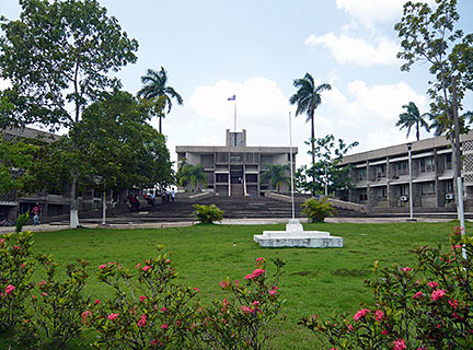 Parliament of Belize, Belmopan Image: Haakon S. Krohn Bookmark/share this page |
| To find a location type: street or place, city, optional: state, country. |
Local Time Belize:
Wednsday-April-17 11:33
Time zone: Central Standard Time (CST) UTC/GMT -6 hours |
|
φ Latitude, λ Longitude (of Map center; move the map to see coordinates): , |
||||||
| Google Earth: Searchable map/satellite view of Belmopan, Belize |
||||||
| More about Belize: Country: Continent: Historically related Countries: External Links: Belmopan online (Belmopan portal) Wikipedia: Belmopan |
Current Weather Conditions Belize, weather station at Philip Goldson International Airport.
|
Related Consumer Information:
|
||||
| Searchable Maps of other Capital Cities in Central America: Guatemala City, Managua, Panama City, San José, San Salvador, Tegucigalpa Searchable Maps of other Countries of Central America: Belize, Costa Rica, El Salvador, Guatemala, Honduras, Nicaragua, Panama |
||||||
Map Help [ show ] |
||||||
One World - Nations Online .:. let's care for this planet Promote that every nation assumes responsibility for our world. Nations Online Project is made to improve cross-cultural understanding and global awareness. More signal - less NOISE |
| Site Map
| Information Sources | Disclaimer | Copyright © 1998-2023 :: nationsonline.org |

