Nations Online
All Countries in the World
Nations Online All Countries in the World | |
Home  |
___ Satellite View and Map of the City of Dresden, Germany |
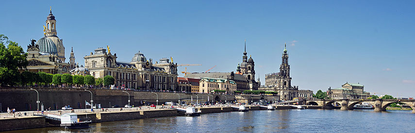 View of Dresden Old Town at Elbe River (Brühl's Terrace). Image: Bgabel |
About Dresden Satellite view is showing Dresden, the capital city of the German Federal Free State of Saxony. The city is located in a valley on the River Elbe in central east Satellite view is showing Dresden, the capital city of the German Federal Free State of Saxony. The city is located in a valley on the River Elbe in central east Dresden has a city population of about half a million inhabitants, 3.5 million people live in the Saxon triangle metropolitan region. 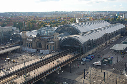 Dresden Central Station. Photo: Hullbr3ach Just zoom in (+) to see the reconstructed Church of Our Lady (Dresden's Frauenkirche). The Map shows a city map of Dresden with expressways, main roads and streets, zoom out to find Dresden Airport located 9 km (5.6 mi) to the north. To find a location use the form below. To see just the map click on the "Map" button. |
|
| To find a location type: street or place, city, optional: state, country. |
Local Time Dresden:
Thursday-April-25 02:00
Standard Time Zone (CET): UTC/GMT +1 hourCEST (Daylight Saving Time) in use from end of March until end of October. Time zone offset: UTC/GMT +2 hours |
 Map of Bavaria Map of Bavaria |
 Map of Berlin Map of Berlin |
 Map of Brandenburg Map of Brandenburg |
|
 Map of Bremen Map of Bremen |
 Map of Hamburg Map of Hamburg |
 Map of Hesse Map of Hesse |
 Map of Lower Saxony Map of Lower Saxony |
 Map of Mecklenburg-Western Pomerania Map of Mecklenburg-Western Pomerania |
 Map of North Rhine-Westphalia Map of North Rhine-Westphalia |
 Map of Rhineland-Palatinate Map of Rhineland-Palatinate |
 Map of Saarland Map of Saarland |
 Map of Saxony Map of Saxony |
 Map of Saxony-Anhalt Map of Saxony-Anhalt |
 Map of Schleswig-Holstein Map of Schleswig-Holstein |
 Map of Thuringia Map of Thuringia |
| Europe Alpha City Tour: Rome - Zürich - Madrid - Paris - Amsterdam - London Stockholm - Berlin - Prague - Vienna - Istanbul Other Major Cities in Western Europe Bern, Brussels, Den Hague, Luxembourg (City), Monaco, Rotterdam, Vaduz |
Map Help [ show ] |
One World - Nations Online .:. let's care for this planet Promote that every nation assumes responsibility for our world. Nations Online Project is made to improve cross-cultural understanding and global awareness. More signal - less NOISE |
| Site Map
| Information Sources | Disclaimer | Copyright © 1998-2023 :: nationsonline.org |

