Nations Online
All Countries in the World
Nations Online All Countries in the World | |
Home  |
___ Satellite View and Map of the Panama Canal close to Panama City (Ciudad de Panamá) |
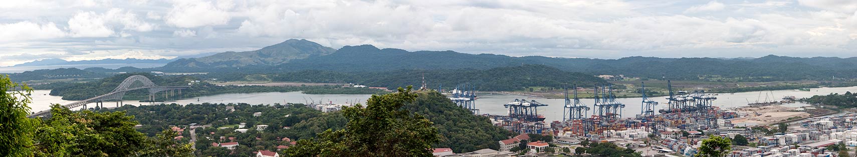 Panorama of Pacific entrance of the canal. Left: Pacific Ocean and Puente de las Americas (Bridge of Pan-American Highway); far right (ouside the image), the Miraflores locks. - Image: Brian Gratwicke |
About the Panama CanalThe Panama Canal connects the Atlantic and Pacific oceans across the Isthmus (a narrow strip of land with sea on either side) of Panama. The canal is about 80 km (50 mi) long.Its construction begun by Ferdinand de Lesseps (builder of the Suez Canal) in 1881, the digging through a long stretch of a hot, mosquito and Yellow Fever invested jungle, literally by hand, was a huge technical challenge at that time (and would be today). The French failed and the project was abandoned in 1889 after years of trial and more errors. At the end of the 19th and the beginning of the 20th century, the "Industrial Age" was already in full swing, and it was the "Golden Age" of ocean-going steamships. Manufacturing and trade were gaining momentum in Europe and the US, more reliable and cost effective transportation was needed for the growth of international trade. |
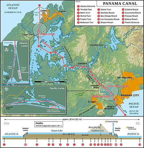 Panama Canal Map. A schematic of the Panama Canal, illustrating the sequence of locks and passages. Image: Thomas Römer, Source: Wikipedia Panama Canal Map |
| The United States were also interested in a shorter ship route to
their west coast, and so in 1904, they bought the French equipment and excavations for US$40 million, paid the new country of Panama US$10 million plus more each year, and began work on the Panama Canal on May 4 of the same year. The canal was completed in 1914. Control of the canal remained with the U.S. until 1999, when it was ceded to Panama. The Panama canal was built to have a maritime short-cut through the Isthmus of Panama, this shortens the shipping routes from the Americas to Asia and Australia by almost half, because ships doesn't have to navigate around South America. In times when the canal was planned and built, the best way to transport large amount of goods, was shipping them, literally by using vessels and ships. Satellite view is showing the southern end of the canal where it meets the Gulf of Panama, Pacific Ocean, close to Panama City, Panama's capital (to the north-east). Zoom out/pan to follow the ship route through the canal (yellow line). The canal's level is 26m (85 ft) above sea level, therefore the Panama Canal locks which lifts a ship up to the main elevation of the canal and down again. To find a location use the form below. To view just the map, click on the "Map" button. |
|
| To find a location type: street or place, city, optional: state, country. | Local Time Panama:
Monday-April-15 2024 08:31
Standard Time Zone: Eastern (EST), UTC/GMT -5 hours |
|
φ Latitude, λ Longitude (of Map center; move the map to see coordinates): , |
||||||
| Google Earth: Searchable Map of the Panama Canal Initial Pacific end of the canal where it meets the Gulf of Panama. Atlantic Entrance 9°23′15″N 79°55′07″W Pacific Entrance 8°53′18″N 79°31′17″W |
Bookmark/share this page |
|||||
| More about Panama: Cities: Country: Continent: |
Weather Conditions Panama
External Links: Panama Canal Authority (official website) The Panama Canal Article about the Panama Canal in "Conflicts in Cosmopolitanism" by Chuck Holmgren. Wikipedia: Panama Canal |
Related Consumer Information:
|
||||
| Searchable Maps of other Countries of Central America: Belize, Costa Rica, El Salvador, Guatemala, Honduras, Nicaragua Country Profiles: Countries and Territories of The Americas |
||||||
Map Help [ show ] |
||||||
One World - Nations Online .:. let's care for this planet Promote that every nation assumes responsibility for our world. Nations Online Project is made to improve cross-cultural understanding and global awareness. More signal - less NOISE |
| Site Map
| Information Sources | Disclaimer | Copyright © 1998-2023 :: nationsonline.org |

