Nations Online
All Countries in the World
Nations Online All Countries in the World | |
Home  |
___ Satellite View and Map of the City of Sendai (仙台), Japan |
Searchable Map and Satellite View of Sendai using Google Earth Data Satellite view showing Sendai, the largest city in Tōhoku in Japan. The capital city of Miyagi Prefecture is located about 370 km (230 mi) north of Tokyo, in a hilly region with dormant volcanoes, near the northeastern coast of Honshu, Japan's main island. Satellite view showing Sendai, the largest city in Tōhoku in Japan. The capital city of Miyagi Prefecture is located about 370 km (230 mi) north of Tokyo, in a hilly region with dormant volcanoes, near the northeastern coast of Honshu, Japan's main island. 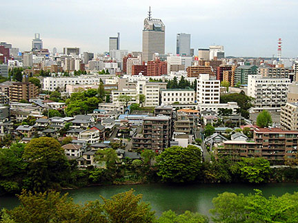 View from Mount Atago on Sendai with Hirose river, which flows 45 km (28 mi) through the city. Image: Kinori Today Sendai has a population of about 1 million inhabitants (2014). One of the 'Three Views of Japan' Matsushima, a group of tiny islands covered with pine trees, is near Sendai, in Matsushima-shi. Sendai has been shaken by several major earthquakes in recent history, in 1978 and in 2005, on 11 March 2011, an 8.9 earthquake with its epicenter 70 km (45 mi) east of Sendai, and a following tsunami hit the city, causing major damage. Sendai airfield was submerged when the tsunami wave swept across the airport, and through the city, washes away everything that was in it, cars, trucks, even buildings. When the water was gone an inconceivably amount of debris littered the streets of Sendai. Sendai's JX refinery on the outskirts of the city went up in flames. The map shows a city map of Sendai with expressways, main roads and streets, and the location of Sendai Airport (IATA code: SDJ). To find a location use the form below. |
|
| To find a location type: street or place, city, optional: state, country. |
Local Time Sendai:
Tuesday-April-23 04:00
UTC/GMT +9 hours |
|
φ Latitude, λ Longitude (of Map center; move the map to see coordinates): , |
||||||
| Google Earth: Searchable Map and Satellite view of Sendai, Miyagi Prefecture, Japan. City Coordinates: 38°16′N 140°52′E |
Bookmark/share this page |
|||||
| More about Japan: Landmarks: Mount Fuji Cities: A searchable map/satellite view and some information about Japan's largest cities: Country: Continent: External Links: Sendai (official city web site) Sendai Airport Wikipedia: Sendai |
Current Weather Conditions Sendai
|
Explore More:
Related Consumer Information:
|
||||
| Major Cities in Eastern Asia Bangkok, Beijing, Busan, Chongqing, Colombo, Delhi, Fukuoka, Guangzhou, Hanoi, Ho Chi Minh City, Hong Kong, Islamabad, Jakarta, Karachi, Kobe, Kolkata, Kuala Lumpur, Kyoto, Lahore, Lhasa, Macao, Manila, Mumbai, Nagoya, Osaka, Phnom Penh, Pyongyang, Sapporo, Seoul, Shanghai, Shenzhen, Singapore, Taipei, Tianjin, Tokyo, Ulaanbaatar, Yangon, Yokohama |
||||||
Map Help [ show ] |
||||||
One World - Nations Online .:. let's care for this planet Promote that every nation assumes responsibility for our world. Nations Online Project is made to improve cross-cultural understanding and global awareness. More signal - less NOISE |
| Site Map
| Information Sources | Disclaimer | Copyright © 1998-2023 :: nationsonline.org |

