Nations Online
All Countries in the World
Nations Online All Countries in the World | |
Home  |
___ Satellite View and Map of the City of Toronto, Ontario, Canada |
 Satellite view is showing Toronto, largest city and the cultural, entertainment and financial capital of 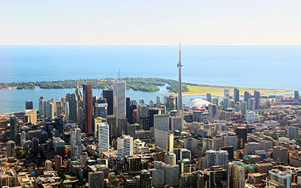 Aerial view of Toronto's central business district with Tower in background. Just zoom in to see CN Tower in downtown Toronto, 553.33 metres (1,815.4 ft) tall, it was the tallest free-standing structure in the world until September 2007. The map shows a city map of Toronto with expressways, main roads and streets, zoom out to see Toronto Pearson International Airport To find a location use the form below. To see just the map click on the "Map" Button. |
|
| To find a location type: street or place, city, optional: state, country. |
Local Time Toronto:
Tuesday-April-16 2024 07:51
Standard time zone Eastern (EST): UTC/GMT -5 hoursDaylight Saving Time (EDT) in use from the second Sunday in March, ends on the first Sunday in November; time zone offset: UTC/GMT -4 hours |
|
φ Latitude, λ Longitude (of Map center; move the map to see coordinates): , |
||||||
| Google Earth: Searchable map/satellite view of Toronto, the capital city of the Province of Ontario, Canada. City Coordinates: 43°42′59.72″N 79°20′26.47″W |
Bookmark/share this page |
|||||
| More about Canada: Cities: Satellite view and maps of other major Cities of Canada: Country: Canada key statistical figures. Continent: |
Current Weather Conditions Toronto
External Links: Toronto Official website of the City of Toronto. Tourism Toronto Official tourism promotion website of Toronto. Wikipedia: Toronto Wikipedia article about Toronto. |
Related Consumer Information:
|
||||
Major U.S. Cities: Atlanta, Atlantic City, Austin, Baltimore, Boston, Charlotte, Chicago, Cincinnati, Cleveland, Columbus, Dallas, Denver, Detroit, El Paso, Fort Worth, Honolulu, Houston, Indianapolis, Jacksonville, Kansas City, Las Vegas, Long Beach, Los Angeles, Memphis, Miami, Milwaukee, Minneapolis, Nashville, New Orleans, New York City, Norfolk, Oklahoma City, Orlando, Philadelphia, Phoenix, Pittsburgh, Portland, Sacramento, St. Louis, San Antonio, San Diego, San Francisco, San Jose, Santa Fe, Seattle, Tampa, Tucson, Washington D.C. |
||
Map Help [ show ] |
||
One World - Nations Online .:. let's care for this planet Promote that every nation assumes responsibility for our world. Nations Online Project is made to improve cross-cultural understanding and global awareness. More signal - less NOISE |
| Site Map
| Information Sources | Disclaimer | Copyright © 1998-2023 :: nationsonline.org |

