var point = new GLatLng(7.5626, 151.7926); var marker = createMarker(point, '

Chuuk<\/h1>Chuuk island group formerly known as Truk island is the most populous of the FSM. Weno is the capital of Chuuk state.

', blue) map.addOverlay(marker); var point = new GLatLng(5.3853, 163.0024); var marker = createMarker(point, '

Kosrae<\/h1>Kosrae island with Tofol the capital of Kosrae state.

', blue) map.addOverlay(marker); var point = new GLatLng(7.0368, 158.1797); var marker = createMarker(point, '

Pohnpei<\/h1>Pohnpei is the main island of Pohnpei state.Situated on the island is Palakir, the capital of FSM.

', blue) map.addOverlay(marker); var point = new GLatLng(9.5986, 138.1647); var marker = createMarker(point, '

Yap<\/h1>Yap is the main island of Yap state.

', blue) map.addOverlay(marker); var point = new GLatLng(7.4576, 151.8402); var marker = createMarker(point, '

Chuuk International Airport<\/h1>a public airport (IATA code: TKK), located on Weno, the main island of the State of Chuuk.

', plane) map.addOverlay(marker); var point = new GLatLng(5.3544, 162.9552); var marker = createMarker(point, '

Kosrae International Airport<\/h1>a public airport (IATA code: KSA), located on Kosrae, the one island state.

', plane) map.addOverlay(marker); var point = new GLatLng(6.9822, 158.2032); var marker = createMarker(point, '

Pohnpei International Airport<\/h1>a public airport (IATA code: PNI), located on Pohnpei island, the capital of the Federated States of Micronesia.

', plane) map.addOverlay(marker); var point = new GLatLng(9.4984, 138.0859); var marker = createMarker(point, '

Yap International Airport<\/h1>is Yap\'s public airport (IATA code: YAP), located on Yap island, the the main island of the Yap state.

 
One Planet
Nations Online

All Countries in the World


___ Satellite View and Map of Federated States of Micronesia (FSM)

Searchable Map and Satellite View of Micronesia using Google Earth Data

Satellite view is showing the Federated States of Micronesia, a Micronesian island nation consisting of a group of four associated island states that comprise the 600 islands of the Caroline Islands in the Pacific Ocean. The 4 island states are Chuuk, Kosrae, Pohnpei and Yap.

The FSM has a population of 110,000 inhabitants. Capital city of Micronesia is Palikir, on the island of Pohnpei.

Spoken languages are English, and the Austronesian languages Chuukese, Kosraean, Pohnpeian, Yapese, Ulithian, and Woleaian (all of them official).

Geograhically relative close to: Guam and Northern Mariana Islands , Indonesia, Papua New Guinea and the Philippines.

The map shows Federated States of Micronesia with islands, cities, towns, and main roads.
To find a location use the form below.
 
Kolonia city, Pohnpei
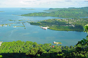
Kolonia city, cultural capital of Micronesia.
To find a location type: street or place, city, optional: state, country.

Local Time Pohnpei:
Saturday-April-20  13:05  
UTC/GMT +11 hours
 
φ Latitude, λ Longitude (of Map center; move the map to see coordinates):
,
 
Google Maps: Searchable Map of Federated States of Micronesia.


More about Micronesia:

Cities/Towns:
Palikir on Pohnpei island (capital district)

Island Nation:
Federated States of Micronesia Profile

Continent:
Map of Micronesia
Map of Oceania/Australia
 
Current Weather Conditions Pohnpei


Related Consumer Information:

 
map pan button
to pan the map click on the respective arrow on the pan button or click on the map and move your mouse/pointer to drag the map around (pan).
zoom to Zoom in +, or Zoom out – use the zoom buttons; or double click on the map to zoom in.
map control buttons Map Type Control Buttons;
To switch between various map types click on this buttons:

 
terrain button
 
Click the Map button for a street map, this button holds the option for
Terrain, it displays a physical map with topographical details.

Labes button
 
Click the Satellite for a satellite image;
with the option to switch Labels (names, borders, roads, business, etc.) on and off, for a combination of satellite image and street map.
Pegman The "Pegman" symbol offers the switch to Google's street view, the 360-degree, panoramic street-level imagery.
To enjoy street views, grab pegman with your cursor and hoover over the map, when street view is available parts of the map will change to blue, drop pegman there and you might have a lot of fun within unimaginable boring landscapes.
 
Other Micronesian Island Nations:
Hawaii, Kiribati, Marshall Islands, Micronesia (Federated States of), Nauru, Northern Mariana Islands, Palau

Countries and territories of Australia/Oceania

Countries of the World: A - C | D - G | H - L | M - P | Q - T | U - Z

Continents: Africa | The Americas | Asia | Europe

Map Help [ show ]
 
up