Nations Online
All Countries in the World
Nations Online All Countries in the World | |
Home  |
___ Satellite View and Map of Nepal |
About Nepal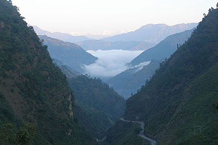 Road through the Mahabharat Range (Lesser Himalaya) near Tansen, Nepal. In the background the Greater Himalaya. Image: Argenberg Nepal is bordered by China (Tibet Autonomous Region (Xizang), and India by the Indian states of Uttarakhand, Uttar Pradesh, Bihar, West Bengal, and Sikkim, and its close to Bhutan and Banglades. With an area of 147,181 km² the country is somewhat larger than 1.5 times the size of Portugal, or slightly larger than the U.S. state of Arkansas. Capital city of Nepal is Kathmandu. Official language is Nepali. The map shows Nepal with cities and towns, main roads and streets. To find a location use the form below. To view just the map, click on the "Map" button. |
|
| To find a location type: street or place, city, optional: state, country. |
Local Time Kathmandu:
Tuesday-April-23 12:35
UTC/GMT +5:45 hours |
|
φ Latitude, λ Longitude (of Map center; move the map to see coordinates): , |
||||||
| Google Maps: Searchable map/satellite view of the Republic of Nepal. |
Bookmark/share this page |
|||||
| More about Nepal: Landmarks: Cities: Country: Nepal key statistical data. Continent: |
Current Weather Conditions Kathmandu
|
Related Consumer Information:
|
||||
| Countries and Territories of Asia | ||||||
Map Help [ show ] |
||||||
One World - Nations Online .:. let's care for this planet Promote that every nation assumes responsibility for our world. Nations Online Project is made to improve cross-cultural understanding and global awareness. More signal - less NOISE |
| Site Map
| Information Sources | Disclaimer | Copyright © 1998-2023 :: nationsonline.org |

