One Planet
Nations Online

All Countries in the World


___ Satellite View and Map of Somalia

 
Mosque opposite the parliament building in Mogadishu
View of a mosque opposite the parliament building in the Somali capital Mogadishu.
Image: AMISOM Public Information
 

Searchable Map and Satellite View of Somalia using Google Earth Data


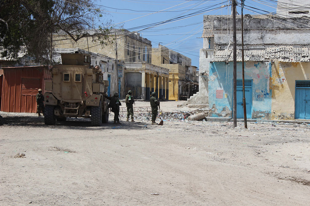
Ugandan troops serving under the African Union Mission in Somalia (AMISOM), patrol the streets of the coastal town of Marka.
Image: AMISOM Photo / Mohamed Haj
Satellite view is showing the Eastern African country on the Horn of Africa, bordering the Gulf of Aden (in north) and the Indian Ocean.

Somalia has a population of 12.3 million inhabitants (in 2014).

Capital city is Mogadishu (Muqdisho). Spoken languages are Somali and Arabic (both official).

Countries with international borders to Somalia are Djibouti, Ethiopia, and Kenya.


The map shows Somalia with cities, towns, expressways, main roads and streets.
To find a location use the form below.
 
To find a location type: street or place, city, optional: state, country.

Local Time Somalia:
Monday-April-22  04:00  
Timezone: EAT, UTC/GMT +3 hours
φ Latitude, λ Longitude (of Map center; move the map to see coordinates):
,
 
Google Maps: Searchable Map of Somalia (Soomaaliya).
 
Bookmark/share this page
Instagram

 
More about Somalia:

Cities:
Searchable Map and Satellite View of the City of Mogadishu

Country:
Political Map of Somalia
Somalia Country Profile

Continent:
Map of Northern Africa and the Middle East
Political Map of Africa
Relief Map of Africa
Google Earth Searchable Map of Africa
 Countries of Africa
Capitals of Africa
Flags of Africa
Languages of Africa

 
Weather Conditions Mogadishu:


Related Consumer Information:


Maps of other Countries in East Africa
Burundi Map | Comoros Map | Djibouti Map | Eritrea Map | Ethiopia Map | Kenya Map
Madagascar Map | Malawi Map | Mozambique Map | Réunion Map | Rwanda Map | Tanzania Map
Uganda Map | Zambia Map | Zimbabwe Map

Interactive Maps of other Countries in East Africa
Burundi Interactive Map | Comoros Interactive Map | Djibouti Interactive Map | Eritrea Interactive Map
Ethiopia Interactive Map | Kenya Interactive Map | Madagascar Interactive Map | Malawi Interactive Map
Mauritius Interactive Map | Mozambique Interactive Map | Réunion Interactive Map | Rwanda Interactive Map
Seychelles Interactive Map | Tanzania Interactive Map | Uganda Interactive Map
Zambia Interactive Map | Zimbabwe Interactive Map

Major Cities in East Africa
Addis Ababa, Antananarivo, Asmara, Bujumbura, Dar es Salaam, Djibouti, Dodoma, Harare, Kampala, Kigali,
Lilongwe, Lusaka, Maputo, Moroni, Mogadishu, Nairobi, Port Louis, Victoria, Zanzibar
 

Map Help [ show ]
 
up