
| Home |
|
|
|
___ Administrative Map of South Korea (Republic of Korea) | |
About South Korea |
|
| Map is showing South Korea, an East Asian nation on the southern half of the Korean Peninsula. The country is bordered by the the Sea of Japan in east and the Yellow Sea in west, the Korea Strait in south. It has one of the world’s most heavily militarized borders with North Korea in north and it shares a maritime border with Japan. With an area of 99,678 km² the country is about the size of Iceland, or slightly smaller than the U.S. state of Pennsylvania. Its landscape offers hills and mountains in particular in the eastern part, most of the terrain is not arable. And there are the Lowlands, wide coastal plains in west and southeast. Highest point is Halla-san with 1,950 m, the extinct volcano on Jeju, the nation's largest island in the Korea Strait, southwest of the Korean Peninsula. South Korea has a population of 51,360,000 people (in 2015), capital and largest city is Seoul. Map shows South Korea and surrounding countries with international borders, provincial boundaries, the national capital Seoul, provincial capitals, major cities, main roads, railroads and major airports. |
 Bookmark/share this page |
 One World - Nations Online all countries of the world |
|
|
||
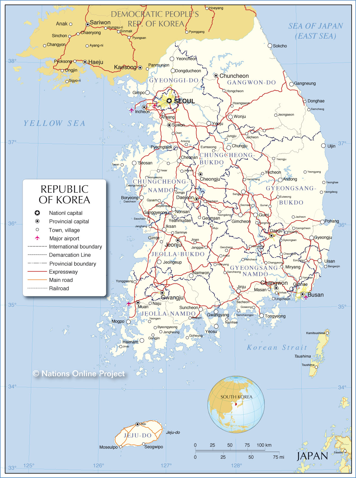 Administrative Map of South Korea Depicted roads are based on the official Expressway Map of Korea |
|||||||||||
| Administrative Divisions of South Korea: South Korea is divided into 8 provinces (do), 1 special autonomous province (teukbyeol jachido), 6 metropolitan cities (gwangyeoksi), and 1 special city (teukbyeolsi). Provinces (province capital in brackets): 1. Chungcheongbuk-do (Cheongju); 2. Chungcheongnam-do (Daejeon); 3. Gyeongsangbuk-do (Daegu); 4. Gyeongsangnam-do (Changwon) 5. Jeollabuk-do (Jeonju); 6. Jeollanam-do (Muan County). Jeju-do (Jeju), the island Jeju is a special autonomous province. Metropolitan Cities: Busan, Daegu, Daejeon, Gwangju, Incheon, and Ulsan. Seoul, South Korea's capital is a special city (teukbyeolsi) |
More about Korea: Cities: Country: South Korea (Republic of Korea): South Korea key statistical data. North Korea (Democratic People's Republic of Korea): North Korea key statistical data. Continent: Political Map of Asia. |
Seoul Current Weather Conditions
Current Weather Conditions Busan
|
Explore More:
Related Consumer Information:
|
||||||||
Maps of other countries in Southeast and Eastern Asia: Bangladesh Map, Bhutan Map, Cambodia Map, China Map, India Map, Indonesia Map, Japan Map Korea (North), Laos Map, Malaysia Map, Maldives Map, Mongolia Map, Myanmar Map Nepal Map, Pakistan Map, Philippines Map Singapore Map, Sri Lanka Map, Taiwan Map, Thailand Map, Vietnam Map | |||||||||||
One World - Nations Online .:. let's care for this planet Every nation is responsible for the current state of our world. |
| Site Map
| Information Sources | Disclaimer: Privacy Policy, etc. Contact: [email protected] | Copyright © 1998-2021 :: nationsonline.org |

