
| Home |
|
|
|
___ Political and Administrative Map of the Maldives | |
About Maldives |
|
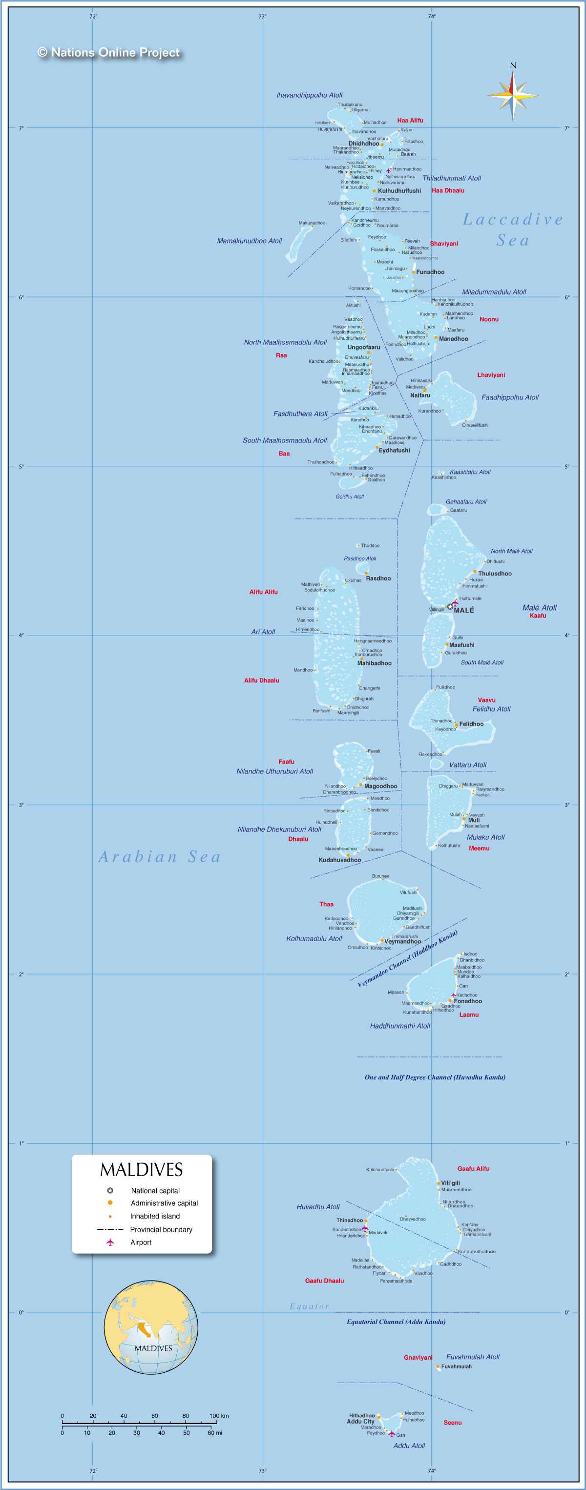
| The Maldives are an island nation in the Laccadive Sea (part of the Indian Ocean), located about 430 km (265 mi) southwest of India. The islands are actually the peaks of a vast submarine mountain range the Chagos-Maldives-Laccadive Ridge, a volcanic ridge and oceanic plateau extending between the Northern and the Central Indian Ocean. The Republic of the Maldives share maritime borders with India, Sri Lanka and the British Indian Ocean Territory (United Kingdom). The archipelago consists of a chain of atolls spread on a length of 860 km from north to south, crossing the equator. The country is made up of about 1200 coral islands grouped into 26 atolls spread over an area of 90,000 km², that's about the size of Portugal, or an area slightly larger than that of the U.S. state of Minnesota. Despite that size, just 1% of the island nation consists of land where people can live, just 300 km² (115 sq mi). The Maldives are the smallest Asian country in both land area and population. The Maldive Islands have a population of approximately 330,000 people (est. 2012), that's about as much as people live in the city of Santa Ana, California, or in the city of Leicester (UK). Capital and largest city is Malé with a population of 100,000 located on the North Malé Atoll. Spoken language is Maldivian, an Indo-Aryan language, spoken almost exclusively on the Maldives. Map is showing the archipelago of the Maldives, the national capital Malé, administrative boundaries, provincial capital islands, inhabited islands and major airports. |
 Bookmark/share this page |
 One World - Nations Online countries of the world |
|
|
||
 Political and Administrative Map of the Republic of Maldives |
|||||||
| Administrative Divisions Depicted on the map are the locations of inhabited islands, they are grouped from north to south by their "atoll names" the administrative divisions in the Maldives (since 2010). Administrative Divisions: 19 atolls and 1 other first-order administrative division (Malé). Atolls with villages and town names (administrative capital in parentheses) [show] |
|||||||
| More about Maldives: Cities: Country: Continent: |
Male Current Weather Conditions
|
Related Consumer Information: |
|||||
Maps of other countries in Southeast and Eastern Asia: Bangladesh Map, Bhutan Map, Cambodia Map, China Map, India Map, Indonesia Map, Japan Map Korea (North), Korea (South), Laos Map, Malaysia Map, Mongolia Map, Myanmar Map Nepal Map, Pakistan Map, Philippines Map Singapore Map, Sri Lanka Map, Taiwan Map, Thailand Map, Vietnam Map | |||||||
One World - Nations Online .:. let's care for this planet Every nation is responsible for the current state of our world. |
| Site Map
| Information Sources | Disclaimer: Privacy Policy, etc. Contact: [email protected] | Copyright © 1998-2021 :: nationsonline.org |
