
| Home |
|
|
|
___ Political Map of Uzbekistan (Republic of Uzbekistan; in Uzbek: Ўзбекистон Республикаси, O‘zbekiston Respublikasi) |
|
About Uzbekistan |
|
| Map is showing Uzbekistan, a landlocked republic in Central Asia that lies south and southeast of the Aral Sea, south of Kazakhstan, north of Turkmenistan and Afghanistan, Tajikistan is bordering in south east, Kyrgyzstan in east. The landscape of Uzbekistan is dry with mostly flat-to-rolling sandy desert, inclusive dunes. The Kyzyl Kum (Red Sand), a large desert stretches across most of the country. Only about 10% of the country's area is intensively cultivated with irrigated land in river valleys and oases. Highest point in Uzbekistan is the Khazret Sultan, at 4,643 m (15,233 ft), the mountain is located on the border with Tajikistan, north west of Dushanbe in the southern part of the Gissar Mountain Range. Main rivers are Amu Darya, Syr Darya (Sirdaryo), and Zarafshan River. With an area of 447,400 km², Uzbekistan is about the size of Sweden, or slightly larger than the U.S. state of California. The country has a population of 31 million people (in 2015). Capital and largest city is Tashkent (Тошкент). Spoken languages are Uzbek and Russian. Depicted on the map are cities, and towns (see below), main roads, railroad and primary airports. |
 Bookmark/share this page |
 One World - Nations Online all countries of the world |
|
|
||
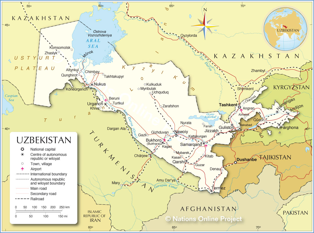 Political Map of Uzbekistan Map based on a UN map. Source: UN Cartographic Section |
|||||||
| Cities and Towns in Uzbekistan Depicted on the map are the location of following Uzbek cities and towns: Almalyk, Altynkul, Andijon, Angren, Bekabad, Beruni, Bukhoro, Chimbay, Chirchiq, Denau, Farghona (Bukhara), Farish, Gazli, Gizhduvan, Guliston, Guzar, Jizzakh, Kagan, Kasan, Kattakurgan, Khiva, Kitab, Komsomolsk, Kulkuduk, Mubarek, Munok, Mynbulak, Namangan, Nawoiy, Nukus, Nurata, Qarshi, Qunghirot, Quqon, Samarqand, Takhtakupyr, Tashkent, Termez, Turtkul, Uchquduq, Urganch, Zarafshon, and Zhaslyk. |
More about Uzbekistan: Uzbekistan key statistical data. Reference Map of Southwestern Asia and the Middle East. |
Weather Conditions Tashkent
|
Related Consumer Information:
|
||||
Other Countries in Central Asia: Maps of other Countries in Central Asia: Afghanistan Map | Kazakhstan Map | Kyrgyzstan Map | Tajikistan Map | Turkmenistan Map |
|||||||
One World - Nations Online .:. let's care for this planet Every nation is responsible for the current state of our world. |
| Site Map
| Information Sources | Disclaimer: Privacy Policy, etc. Contact: [email protected] | Copyright © 1998-2021 :: nationsonline.org |
